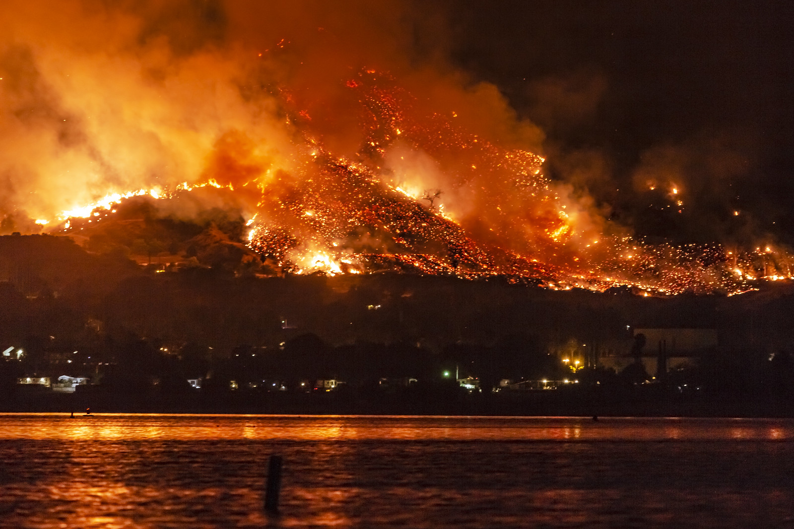
The devastation caused by California wildfires is more than just a natural disaster—it’s a human tragedy. Families flee their homes as flames consume everything in their path, and thick smoke turns the sky into an ominous orange haze. Preventing wildfire tragedies requires more than just emergency response; it demands real-time data and AI-powered wildfire detection to stop fires before they escalate.
Yet, despite advancements in AI and satellite technology, many communities remain vulnerable. Why does critical information arrive too late? Why must tragedy expose the gaps in fire prevention systems? The answers lie in outdated infrastructure, limited accessibility to real-time fire alerts, and the increasing impact of climate change and human negligence.
This blog explores the growing threat of California wildfires and how exci’s AI-driven fire detection and real-time data can revolutionise wildfire prevention. By understanding the root causes of delayed response and embracing innovative solutions, we can shift from crisis management to proactive fire prevention, ultimately saving lives, homes, and ecosystems.
The Perfect Storm
Climate Change and Santa Ana Winds
California has always faced wildfire risks, but recent years have brought unprecedented extremes. Climate change has created a perfect storm. Declining winter rainfall and “climate whiplash”—sudden swings between wet and dry weather—fuel the crisis. In wet years, vegetation grows quickly, only to dry out and become tinder during prolonged droughts. These conditions make wildfires inevitable.
The infamous Santa Ana winds turn these fires into disasters. Gusts reaching 50 to 80 mph (80 to 130 km/h) spread flames at terrifying speeds.
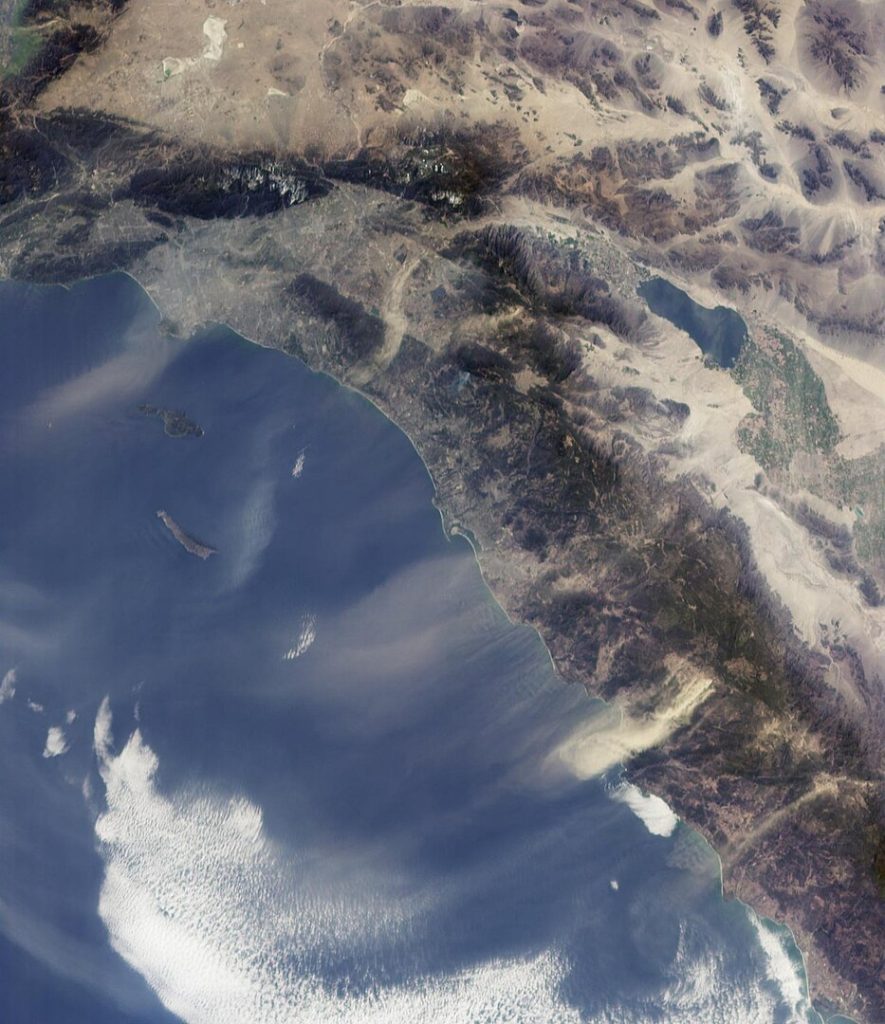 Santa Ana Winds – By NASA/JPL-Caltech – http://photojournal.jpl.nasa.gov/catalog/PIA03445, Public Domain, https://commons.wikimedia.org/w/index.php?curid=306614
This year, intense winds and extended drought conditions have worsened the crisis. Wet years fueled vegetation growth, but dry spells left the landscape dangerously flammable.
The winds have forced over 100,000 people to evacuate and destroyed homes and infrastructure. By mid-January, fires raged across the region, including in iconic areas like Hollywood. Firefighting efforts, though heroic, couldn’t stop the spread. Water shortages, parched vegetation, and relentless winds made containment difficult. With no significant rainfall in sight, the region remains at high risk.
The evidence is clear: climate change is here, intensifying natural disasters and straining ecosystems. Human activities, especially fossil fuel consumption, worsen the problem and accelerate the crisis.
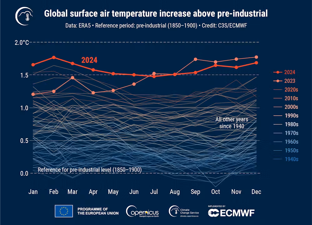 Graphic from Copernicus showing Earth experienced record high temperatures in 2024 Copernicus
The Fossil Fuel Industry
Prioritising Profits Over the Planet
The fossil fuel industry drives climate change by releasing massive amounts of greenhouse gases into the atmosphere. Yet, it continues to prioritize profits over sustainability. This approach is not only short-sighted—it’s reckless. It ignores ecological limits and threatens the delicate balance of life on Earth.
California’s wildfires reveal this systemic failure. Profit takes precedence over environmental health, accelerating destruction. While the fossil fuel industry’s practices amplify the fire risk, another critical challenge looms: the heartbreaking lack of real-time information when needed most.
 Power station – Image by Steve Buissinne from Pixabay
The Heartbreak of Missing Information
Wildfires devastate not only with flames but also with helplessness. For many, the absolute horror isn’t just the fire—it’s the absence of timely, critical data when they needed it most.

Dr. Pagán’s Personal Story
Dr. Brianna Pagán experienced this firsthand. When the Palisades Fire destroyed her home, she could not access real-time satellite data despite her expertise in remote sensing. In addition, power outages, poor cell reception, and missing fire map updates left her without critical information.
The Limitations of Existing Technology
She relied on unreliable crowdsourced updates. NASA FIRMS and other technologies failed to provide the high-resolution, real-time data she needed. Dr. Pagán criticised the geospatial industry for prioritising military and commercial interests over humanitarian needs.
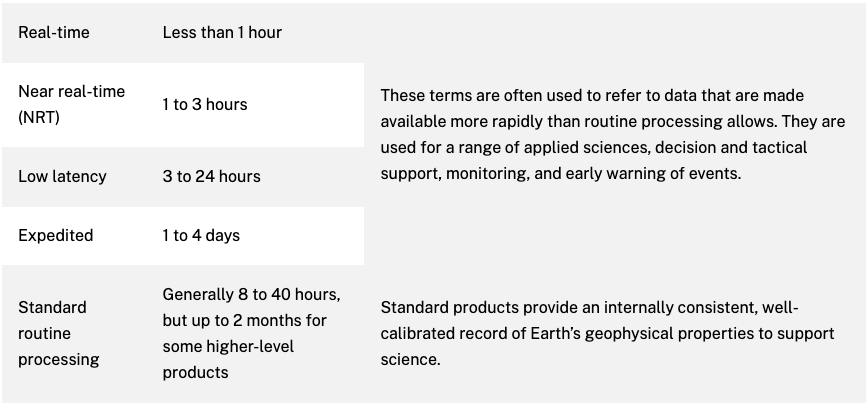 Terms for latency defined and agreed upon by participants across NASA for all data managed by EOSDIS
A Call for Change: Making Real-time Data Accessible
Dr. Pagán called for open, user-friendly disaster data systems integrated with official communication channels. These systems should focus on saving lives, not profits.
The Painful Truth – Inaccessible Satellite Data
Life-saving satellite technology exists, but it’s often inaccessible for most people when it matters most. Communities face wildfires unprepared—not because solutions don’t exist, but because access, reliability, and usability remain out of reach.
Why the Community Was Left in the Dark
The true horror of wildfires wasn’t just the flames—it was the lack of life-saving data. Families scrambled to evacuate, but power outages, downed cell service, and inaccessible real-time satellite data left them without the desperately needed information. Despite technological advances, mismanagement and barriers blocked access to these tools, leaving families to make life-or-death decisions in confusion. What went wrong?
Systemic Failures
- Data Latency: NOAA’s Joint Polar Satellite System (JPSS) crosses the equator 14 times daily to provide global coverage twice daily. However, its satellite data can take hours to process, and conditions may have changed by the time it becomes available. This leaves communities without timely information for critical decisions like evacuations.
- Geostationary Satellite Limitations: While geostationary satellites monitor continuously, their lower resolution and slower processing times delay fire detection. By the time the data was ready, the fast-moving fires were already out of control. Residents had no timely guidance.
- Resolution Limitations: Public satellite systems like FIRMS lack the resolution to detect small, emerging fire hotspots. First responders and residents couldn’t track developing fires, risking their safety.
- Limited Accessibility: Satellite data is often restricted, especially in crises. Services like NASA’s FIRMS aren’t designed for real-time, user-friendly access. Communities were forced to rely on unreliable, crowdsourced data, complicating evacuation and protection efforts.
Public Alert System Failures
- Erroneous Notifications: Public alert systems failed to deliver accurate warnings. Evacuation orders sometimes reached areas already consumed by flames or missed residents entirely. This caused confusion and panic.
- Delayed Warnings: The delay between fire detection and issuing alerts left communities unprepared. This gap eroded trust in official communication channels at a critical time.
Infrastructure Challenges
- Power Outages and Connectivity Issues: The fires disrupted power supplies and cell networks. This prevented many communities from receiving alerts, accessing satellite data, or contacting emergency services.
- Water Supply Limitations: As demand surged, water hydrants ran dry. Nearby reservoirs needed repairs, reducing the community’s ability to fight fires or buy time for evacuation.
The Role of Private Satellite Providers
Private satellite companies like Maxar and Planet Labs operate high-resolution satellites. They offer rapid tasking and near-real-time imaging. However, these services are often inaccessible in fast-moving disasters and are typically available only to paying clients.
The Challenge of Real-Time Wildfire Response
Real-time wildfire response requires integrating satellite imagery with ground-based observations, AI analysis, and public communication systems. While solutions like FireSat are in development, they are not widely accessible.
The Accessibility Gap: Profit vs. Humanitarian Needs
The gap between public and private access to fire data is concerning. Life-saving information is often locked behind paywalls, prioritizing profit over humanitarian needs.
NASA’s Operational Disruptions Amid the Los Angeles Fires
The challenges of accessing crucial data were further highlighted by disruptions experienced by NASA’s Physical Oceanography Distributed Active Archive Center (PO.DAAC) and Jet Propulsion Laboratory (JPL). Due to high winds, power outages, and evacuations, NASA’s data processing capabilities were temporarily halted. This impacted real-time data, including Soil Moisture Active Passive (SMAP) and Microwave Limb Sounder (MLS).
This disruption underscores the vulnerability of data infrastructure during fast-moving disasters. It highlights the need for complementary systems that can provide critical information more quickly and accurately in real-time.
If you want to learn more about satellites’ limitations, check out this link.
exci’s AI and Real-Time Data
A Game-Changer in Preventing Wildfire Tragedies
Wildfires are an escalating global threat, demanding innovative solutions for early detection and swift response. While satellites contribute valuable data, exci’s AI-powered wildfire & bushfire detection system delivers faster, more precise real-time wildfire alerts and enhanced monitoring capabilities.
At exci, we are dedicated to making a difference. Our cutting-edge, Australian-made AI-driven system provides real-time wildfire detection, enabling diverse industries to proactively safeguard their assets and communities.
How exci Works
exci places high-resolution cameras in strategic locations to monitor critical areas. These cameras capture images, which are then analyzed by advanced AI algorithms to detect smoke. This allows exci to detect wildfires within minutes, enabling quick action to save lives, property, and ecosystems.
For instance, during the January 2025 wildfires in Los Angeles, detection times varied. The Kenneth Fire was quickly reported, but the Pacific Palisades fire experienced major delays—evacuation orders came only after homes had already ignited. These cases highlight the urgent need for faster detection and communication, which exci’s early AI wildfire fire detection system addresses effectively.
The Advantages of Ground-Based Systems
exci’s AI-powered system provides significant benefits over traditional satellite systems:
- Real-Time Detection: Ground-based cameras offer continuous monitoring, enabling near-instantaneous detection of wildfire indicators.
- High Accuracy: exci’s advanced deep learning algorithms provide robust, real-time alerts with a near-zero false positive rate.
Reduced Latency: Unlike satellites, which can take hours to deliver data, exci’s system provides immediate feedback, allowing rapid decision-making.
Integrating Satellite Data for Enhanced Coverage
exci enhances satellite capabilities by integrating ground-based camera data with satellite imagery. This enables rapid and accurate bushfire detection. This combination allows for rapid and precise wildfire detection and monitoring.
Ground-based cameras offer quick detection during the day, while satellites provide wide-area coverage, nighttime fire detection, and reliable performance in remote or harsh conditions.
Real-Time Fire Management

AI Wildfire Monitoring Needs Public Funding
Reliable, real-time information is crucial in the fight against wildfires, which increasingly threaten communities, infrastructure, and ecosystems. To safeguard lives and assets, governments must invest in real-time fire alerts and monitoring systems.
Australia’s Bureau of Meteorology (BoM) demonstrates how public funding can support critical services that help communities prepare for extreme weather. A similar commitment should extend to early fire warning systems. exci’s AI-powered system provides real-time insights, enabling faster, data-driven decisions to mitigate wildfire risks and enhance emergency response.
exci (formerly Fireball International) commissioned the Australian National University (ANU) to assess bushfire costs from 2020 to 2049. The study estimated annual costs could reach A$2.2 billion, with Black Summer-scale events driving even higher expenses. However, ANU highlights that early fire detection investments could save up to A$14.4 billion over the same period, underscoring the value of proactive measures in a warming climate.
A Call to Action: Concrete Steps for Change
California’s wildfires underscore the urgent need for systemic change. Here’s how governments, industries, communities, and individuals can take action:
- Governments must accelerate the transition to renewable energy, enforce stricter building codes, and invest in sustainable land management. They should also fund life-saving technologies like exci’s AI-powered forest fire monitoring system to enhance early detection and rapid response.
- Industries must adopt greener technologies, reduce greenhouse gas emissions, and integrate AI-driven solutions to protect critical infrastructure and improve situational awareness during crises.
- Communities should advocate for stronger environmental policies, support renewable energy initiatives, and engage in fire preparedness efforts to safeguard local ecosystems.
- Individuals can reduce their carbon footprint, conserve water, minimize waste, and create defensible spaces around their homes. Small actions—such as using public transport, reducing energy consumption, and staying informed about fire safety—can collectively make a significant impact.
By working together, we can build a more resilient future and mitigate the growing threat of wildfires.
Preventing Wildfires with Innovation and Collaboration
The California wildfires are a stark reminder of the escalating threats posed by climate change, human negligence, and systemic failures. Behind the flames are heartbreaking stories of lives uprooted, homes destroyed, and communities left vulnerable—not because solutions don’t exist, but because access to critical, life-saving technologies remains limited.
It doesn’t have to be this way. By embracing innovation, like exci’s AI-driven fire hazard detection system, and prioritising the dissemination of timely, accurate information, we can better equip communities to confront this growing crisis.
The path forward requires collaboration between technology providers, policymakers, and communities. Together, we can shift from a reactive approach to proactive prevention—mitigating the devastating impacts of wildfires, saving lives, and preserving what matters most.
by Gabrielle Tylor
exci – Smoke Alarm for the Bush
Proven Early AI Wildfire & Bushfire Detection Technology
Don’t let Hazardous Events become Catastrophic!
exci has evolved from delivering AI-powered wildfire detection to offering a complete turnkey solution. By expanding our services, exci offers a One-Stop Solution for comprehensive bushfire detection, management, and network connectivity. Proudly Australian-made and owned, we provide a complete package that includes:
- AI-driven detection system for fast, accurate and reliable early wildfire detection
- Expertly designed and installed hardware for seamless fire monitoring
- Custom tower solutions tailored to your specific location and needs
- Complete expert installation and maintenance services
- Real-time camera access and control allow immediate situational awareness and informed decision-making during wildfire events.
Secure your assets, enhance your fire response capabilities, and experience peace of mind with exci’s innovative AI forest fire detection and monitoring service.
Contact us today to discover how we can tailor our AI-powered wildfire/bushfire detection and network solutions to suit your unique needs.
Email: info@exci.ai
International: +61 458 594 554
Australia: 1300 903 940